
Before the Flood Arrived: What Did Nepal Know And When?
Nepal's official timeline shows that authorities began receiving information about the devastating Rasuwa flood around 9 AM, with mass SMS warnings following shortly afterward. While communities farther downstream potentially had more time to react, those near the Tibet border faced a much shorter warning window. The key unanswered question is whether information from upstream could have reached Nepal earlier and provided more time to save lives.
· 9 min read
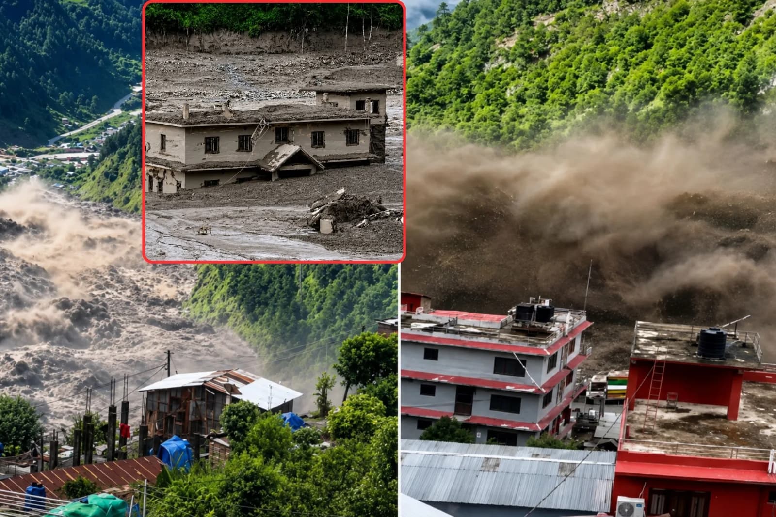
The devastating flood that entered Nepal through Rasuwa on August 26, 2026(Bhadra 10,2083), moved rapidly through the Bhote Koshi Trishuli river system, killing people, sweeping away settlements and infrastructure, and leaving hundreds missing.
In the first hours after the disaster, there was confusion over what had happened high in the mountains. Some early reports pointed to an earthquake. Others suggested a glacial lake outburst flood. Scientists later began focusing on a massive collapse of ice and rock upstream in Tibet.
But alongside the question of what caused the flood, another question deserves attention:

When did Nepal know that a major flood was coming, and how much time did people actually have to get to safety?
A technical report released by Nepal's Department of Hydrology and Meteorology (DHM) now provides the clearest official timeline of how the flood was detected and how warnings were issued.
What the government report shows
According to DHM's technical report, a seismic event initially measured at magnitude 4.4 was recorded at 8:37 AM.
At 8:40 AM, the Bhote Koshi monitoring station at Syabrubesi recorded the river at approximately 1.62 metres, well below its warning level of 6 metres and danger level of 7 metres.
Around 8:50 AM, however, data from the station stopped being received.
The report says that at approximately 9:00 AM, the Flood Forecasting Division received information from the Rasuwa District Administration Office and local representatives that a major flood had entered the Bhote Koshi from the Tibet side.
By 9:15 AM, preliminary SMS warnings were being sent to vulnerable river areas in Rasuwa, Nuwakot, Dhading and Chitwan.
At 9:16 AM, a wider warning was distributed through Nepal Telecom and Ncell. DHM says a total of 6,79,295 warning SMS messages were sent, 4,35,635 through Nepal Telecom and 2,43,660 through Ncell.
The official timeline therefore raises an important period for further investigation: what happened between the first major physical signal around 8:37 AM and the point when Nepal's flood forecasters received information about the incoming flood?
That should not automatically be described as a failure or delay. It first needs to be established whether actionable information about the flood existed during those minutes.
What Nepal's hydrologists have said
There are slight differences in the publicly reported times.
The Kathmandu Post quoted senior divisional hydrologist Binod Parajuli of the Flood Forecasting Division as saying the division received information about the flood at around 8:56 AM through the Rasuwa District Administration Office and the National Disaster Risk Reduction and Management Authority.
Parajuli said a downstream warning was issued within approximately four minutes.
The DHM technical report, meanwhile, places the receipt of information at around 9:00 AM, followed by preliminary SMS warnings around 9:15 AM and wider dissemination at 9:16 AM.
These times do not necessarily contradict each other. They may represent different stages: receiving initial information, issuing an operational warning, and beginning mass SMS distribution.
What scientists think happened upstream
Scientists are also gradually changing the understanding of what physically triggered the disaster.
Rijan Bhakta Kayastha, a professor and climate researcher at Kathmandu University, told the Kathmandu Post in an early assessment that an ice avalanche may have blocked the Lhende River, causing water to accumulate before being released downstream.
Kayastha also said at the time that it would take further investigation to determine exactly what happened.
Other scientists have reached a similar preliminary conclusion.
Glacial geomorphologist Levan Tielidze of Monash University, writing in The Conversation, said early evidence pointed towards an abrupt glacier collapse or enormous ice and rock landslide rather than a conventional glacial lake outburst flood.
CNN, citing scientists examining satellite imagery, also reported that a huge section of glacier appears to have broken away and crashed into the valley around the Lhende River.
But scientists are still trying to explain exactly how that collapse produced such an enormous volume of water and debris.
That uncertainty is important. The disaster should therefore not yet be described simply as a conventional GLOF unless later scientific evidence confirms it.
The earthquake explanation also changed
One of the biggest changes since the first reports concerns the supposed earthquake.
Initially, a seismic event around 8:37 AM was reported as a magnitude 4.4 earthquake, raising the possibility that an earthquake had triggered the disaster.
Later analysis changed that picture.
According to a report citing the US Geological Survey, the seismic signal appears to have been generated by the enormous landslide or glacier collapse itself rather than by a separate earthquake that triggered it.
In other words, the current evidence points more strongly towards:
ice-rock/glacier collapse → powerful seismic signal → material enters the Lhende River → water and debris move downstream.
The exact process between the collapse and the catastrophic flood remains under scientific investigation.
What Nepal's disaster authority knew
There is another important piece of the information chain.
The Kathmandu Post quoted Shanti Mahat, spokesperson for the National Disaster Risk Reduction and Management Authority (NDRRMA), saying the authority had received preliminary information that an ice avalanche had blocked a river.
According to Mahat, that information came through ICIMOD, which had received information from sources in China.
But she also said at the time:
“We have not received any official information yet.”
That distinction is significant.
It suggests there were different channels of information: local authorities, Nepal's disaster agencies, ICIMOD and sources across the border.
What remains unclear is exactly when each institution received that information.
Did information about the upstream collapse or blockage reach Nepal before the flood crossed the border? Or was the information received only after the disaster was already unfolding?
Without timestamps, that question cannot yet be answered.
A warning system losing its eyes
The DHM report also shows the difficulties forecasters faced once the disaster began.
The Syabrubesi monitoring station stopped transmitting around 8:50 AM. Other monitoring infrastructure farther downstream was also damaged as the flood travelled through the river system.
According to DHM's reconstruction, the flood reached the Galchhi area at around 10:28 AM, Malekhu Bazaar at around 11:50 AM, crossed Muglin around 1:00 PM, and reached the Narayani at Devghat around 3:20 PM.
DHM estimates the river distance between the Tibet-Nepal border and Devghat at approximately 168 kilometres.
The farther downstream the flood travelled, the more time authorities had to warn communities.
That means the experience of someone living near the border may have been completely different from that of someone living near Malekhu or Muglin.
Did the warnings reach people in time?
DHM says nearly 6,80,000 SMS warnings were distributed during the disaster.
That is important evidence that Nepal's warning system was operating.
But the number of messages sent does not by itself tell us whether warnings reached the most vulnerable people with enough time to act.
That requires another layer of evidence.
Residents of Timure, Syabrubesi, Betrawati, Galchhi, Malekhu and other river communities should be asked when they first learned about the flood, whether they received an SMS, what time it arrived and how much time remained before the water reached them.
Their phone screenshots and message timestamps could become some of the most valuable evidence in reconstructing the warning timeline.
For communities farther downstream, the warnings may have provided substantial evacuation time and potentially saved lives.
For communities close to the Nepal-China border, the available warning window may have been much smaller.
Could Nepal have known earlier?
There are actually two different questions.
The first is:
Could scientists have predicted the glacier or ice rock collapse before it happened?
The answer may ultimately be no. Sudden high-altitude collapses can be extremely difficult to forecast.
But the second question is different:
Once the collapse happened, could the resulting flood have been detected earlier and communicated to Nepal before it reached vulnerable settlements?
Answering that requires information from Nepal, China and scientific institutions monitoring the Himalayas.
Researchers need to establish when the collapse occurred, whether the river was blocked, how long any temporary blockage existed, when the water was released, when Chinese authorities or scientists detected the event, and when that information reached Nepal.
One especially important unanswered question is how long the Lhende River may have remained blocked.
If the blockage lasted only minutes, the possible warning window may have been extremely short. If it existed significantly longer, then the question of upstream monitoring and cross-border communication becomes much more important.
At present, there is not enough verified evidence to choose between those possibilities.
Nepal was already investing in early warning
The disaster also comes as Nepal is expanding its climate and glacial flood monitoring systems.
In July 2025, the Green Climate Fund approved a $36.1 million grant for a seven-year project led by DHM with UNDP to reduce glacial flood risks. Together with government and partner co-financing, the programme was valued at nearly $50 million.
The project includes stronger hazard monitoring, more observation infrastructure and improved early warning systems.
But the existence of that project should not be used to claim that Nepal received $50 million and therefore should have prevented this disaster.
The project is still being implemented, covers specific risks and locations, and its actual progress by August 2026 needs to be examined.
There is also a deeper technical question.
A warning system designed primarily to monitor rainfall, river levels and known dangerous glacial lakes may face serious limitations when confronted with a sudden ice rock collapse in a remote mountain valley across an international border.
That leads to perhaps the most important long-term question:
Was Nepal's early warning system designed for the type of disaster that actually struck Rasuwa?
What remains unknown
The DHM report has given the public a much stronger timeline of what happened once the flood entered Nepal.
Scientists have also begun providing a clearer picture of what may have happened high in the mountains.
But the two timelines, the movement of the water and the movement of information, are not yet fully connected.
Several timestamps remain critical: when the glacier or ice rock mass collapsed; when the Lhende River was blocked; how long that blockage lasted; when the destructive water was released; when authorities or scientists in China first detected the danger; when Nepal first received that information; and when people closest to the border actually received a warning.
Those answers may eventually show that the disaster developed too quickly for meaningful advance warning near the border.
They may show that Nepal's warnings worked effectively farther downstream.
Or they may reveal gaps in monitoring, communication or cross-border information sharing that need to be corrected.
The evidence is not complete enough yet to make that judgment.
For now, the most important question remains remarkably simple:
Before the flood arrived, what did Nepal know and when did it know it?
Sources: Government of Nepal Department of Hydrology and Meteorology technical report on the Bhote Koshi Trishuli Narayani flood; Kathmandu Post reporting and interviews with DHM, NDRRMA and Kathmandu University experts; scientific assessments reported by CNN and the US Geological Survey; Levan Tielidze's analysis in The Conversation; ICIMOD-linked preliminary information; and UNDP/Green Climate Fund documentation on Nepal's glacial-flood risk reduction programme.
Published Aug 28 in Researched Article